Showing posts with label technology. Show all posts

Tuesday, October 13, 2009

Bicycle Maintenance and Repair Sites

I'm learning more about maintaining and repairing my mountain bike. In the process, I'm accumulating links to online guides that detail various mechanical procedures. To get them all in one convenient space, I decided to create a single blog post with the links, and as I find more such sites, I will continue to update this page. Any suggestions are most welcome.

Sites with Videos


Sites with Text and Graphics

Friday, July 31, 2009

Planned Percy Priest Perception Paddle


First, alliteration is cool.

Second, the past couple of sea kayak excursions have been preparatory trips for an upcoming paddle that will go the length of J. Percy Priest Lake. Team Essence was interested in (a) campsites around the halfway point and (b) the ease with which we could handle 10+ miles in the kayaks.

I've mentioned in a past post the efficiency that online mapping tools bring to trip planning. Instead of a topo map, this upcoming float was plotted quickly with bing™ maps (formerly Live Search maps), exported as a GPX file, and uploaded to Everytrail for inclusion in this post. I'll eventually mark my waypoints along the float and upload the two routes (Day 1 and Day 2) to my handheld Garmin just so we don't take any wrong turns out on the water.

Mona to Priest Dam - Day 1 at EveryTrail

Map created by EveryTrail: Travel Community

The first day will entail a put-in at the Mona boat ramp on the East Fork of the Stones River. We've paddled down there a couple of times before, including a float/drag of the East Fork that took out at Mona. From the launch, we'll paddle roughly 12.5 miles to one of the islands we scouted, pitch a couple of tents, eat some lovely dehydrated/rehydrated food, and maybe build and tend a small camp fire. The past couple of outings, we've paddled 8 to 9 miles easily in just over two hours, so the 12-mile leg should not be all that strenuous.

Next morning, we'll crank out another 10+ miles to the Hermitage Public Use Area just beside Percy Priest dam. In all, we will have paddled at least 23 miles, probably a little more, and covered Priest lake from its headwaters all the way to its end point. Should be fun.

Mona to Priest Dam - Day 2 at EveryTrail

Map created by EveryTrail: Geotagging Community

Wednesday, May 27, 2009

Panopticon


Though a topo map is a handy thing to have in the field, gone are the days when a USGS map was the main tool for planning an outdoor excursion. So much more visual information is available today via sites like Google Earth and Microsoft Virtual Earth. Lately, I've been exploring some of these sites and learning to use their features.

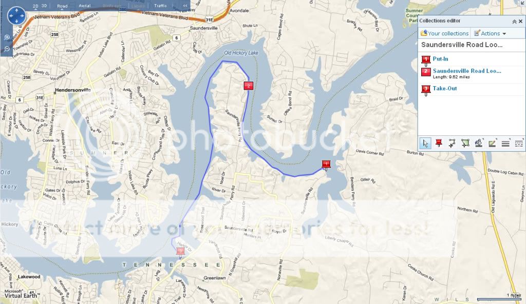
Here, for instance is a kayak paddle planned for Friday on Old Hickory Lake that I charted with Live Search Maps. Using the route feature, I was able to track a path that hugs the shore line and determine the paddle would be over 9 miles long.

Photobucket

The lake features can be viewed with a pretty fine-grained lens, either with an Aerial view as shown here at the put-in.

Photobucket

Or with a Bird's Eye view as shown here at the take-out.

Photobucket

I can also download this charted path as a .gpx file, label the various waypoints, and upload the route to my Garmin handheld should I need navigational assistance on the lake. Information can also go in the opposite direction if I want to save a track on my handheld and then view that track as plotted over an Aerial or Road view of the terrain. Another nice feature is that driving directions are readily called up to the take-out, to the put-in, or between the two.

In the past week or so, I've used Live Search Maps to create a couple of routes for upcoming paddles, and those routes are now loaded up on the Garmin after a bit of finagling with a freeware application called EasyGPS. One is a 20+ mile trip from the Mona launch on the Stones River up to the Anderson Public Use Area on Percy Priest. The other is a river float on the Painted Rock River down in Alabama. I am looking forward to those overnight paddles this summer.

The world is getting smaller and smaller, and our vantage points are getting more powerful all the time.

Update: Live Search Maps is now Bing maps.