
Thursday, August 27, 2009
Hammy East and Lock 4 Loops
Yesterday, I did a loop at Hamilton Creek East with Jimmy. Good ride, though my rear brakes mysteriously jammed about half-way through. Thankfully, Carl at Sun & Ski had given me a five-minute brake and derailleur lesson, and I was able to make a quick adjustment and keep riding. We also hit a paved loop east of the trail and zipped over the BMX track a couple of times. That BMX track was a lot of fun. Below is the capture from Jimmy's new Garmin 300 handheld GPS. We rode a little over 6 miles in all.
A quick gear note... For my anniversary, one of my presents was a Lizard Skins tube insulator for my Camelbak reservoir. It works as advertised. I'm thrilled I don't have to suffer the dreaded hot sip of water anymore.
Hamilton Creek 8-27-09 at EveryTrail
Map created by EveryTrail: Travel Community
Today, I rode again with Jimmy and Dan, this time a loop over at Lock 4, my favorite mountain bike trail in the area. It's just a good single track with a lot of stretches that allow for speed, and it offers several challenging climbs for me. I can tell I'm making gradual improvements in my riding. Today, I powered through all the climbs, and I rode most of the trail one to two gears higher than I have in the past. I also cleared obstacles that have forced me to clip out before. Below is my capture of the approximately seven-mile trail.
One place I did clip out and was glad for it involved the highest log jump on the trail. Just down about 25 yards stood a smallish 8-point buck with a pretty good sized rack still covered in velvet. Since I'd gotten off my bike, he didn't spook, and I just eased down the trail toward him, talking the whole time. He let me get within about fifteen feet and just stood there eating and watching me. Like the deer at Radnor, the ones at Lock 4 are so used to humans that they're basically big pets. Saw four more deer over the course of the loop, one of them a spotted fawn who defiantly blocked the trail until I said something.
Lock 4 Ride at EveryTrail
Map created by EveryTrail: Share and Plan your Trips
Tuesday, August 18, 2009
Hamilton Creek Bailout
Note to self: Get a headlamp for the bike pack.
I hit the Hamilton East trailhead around 6:45, thinking I'd have an hour or so to ride out the trail, but with the fairly dense canopy, it got dark quicker than I thought. My yellow-tinted glasses helped for a while, but by the time I hit the grassy stretch beside the lake, it had gotten too dark to ride with any confidence. The trail was also slippery from some light showers yesterday and today, and my back wheel had been spinning out on roots and rocks the entire ride. When I popped out of the woods, I just called it quits and went over to ride some of the paved road behind the BMX track.
The Garmin put me at 3.41 miles from start to finish on the trail alone. No idea how far I rode on the pavement. The asphalt riding did help clean off my tires, but I also ate a lot of mud splatter.
Hamilton Creek Bail at EveryTrail
Map created by EveryTrail: Share and Plan your Trips
Friday, August 14, 2009
Long Hunter Bonk
This evening, I went over to ride Long Hunter with Jimmy. I started the nearly 3.5 mile trail aggressively and really went after the rocky, root-filled terrain. What I learned is that the trail rides much easier this way. Speed and attack help with finding some flow over the bumps. What I also learned, however, is that I need considerable energy to ride this style. I was already tired from running earlier in the day, and I began to feel the beginnings of a bonk coming on. About halfway through, I let Jimmy take lead and just rode it out a little slower.
Long Hunter Trail at EveryTrail
Map created by EveryTrail: Travel Community
We started another loop after a short breather. Despite downing a mango Cliff Shot Energy Gel (that tasted like mango gone terribly, terribly wrong), I still didn't feel up-to-speed, so I just rode the shorter 1.5 mile return loop. Close to 5 miles total for me.
Long Hunter Return Loop at EveryTrail
Map created by EveryTrail: Share GPS Tracks
Just for kicks and giggles, here are the two tracks overlaid. When you zoom in on the return loop, it appears the Garmin is doing a pretty consistent job of recording tracks. Today, I used the same settings as yesterday: distance sampling every .01 mile.
Long Hunter Combined at EveryTrail
Map created by EveryTrail: Share and Plan your Trips
Thursday, August 13, 2009
Hamilton Creek Thursday Ride
Jimmy and I rode Hamilton Creek East this evening. We did the whole loop and then went back and rode the short, top loop again. All told, somewhere just over 6 miles. It was Jimmy's first time on the trail, and his assessment was "Long Hunter Advanced." Both trails do share a lot of rocky conditions that add that extra bit of jolt. I heard one rider complaining about the trail beating her up just before she headed into the woods. Glutton for punishment, I guess.
With a riding companion, I felt comfortable enough to tackle more obstacles, and I managed to clear a few I hadn't before. I also scouted several new lines through some rocky sections. Baby steps and slow progress.
When we got back to the parking lot the first time, it looked like a mountain bike race had broken out since SORBA (Southern Off-Road Bicycle Association) holds a group ride there every Thursday evening. Wish I'd snapped a pic or two of all the bikers.
Charted the East trail with the Garmin using different settings, and I came up with a 4.5 mile ride again. The match with the last Garmin track was reassuring. With the iPhone reporting such a low number before, I'm assuming the difference had to do with canopy interference. One of the selling points of the Garmin 60CSx is its ability to receive signal even under pretty good cover. Sounds like I'll just be using the Garmin for mountain bike tracking from here out.
Settings this time were to sample distance intervals every .01 mile (or roughly every 50 feet). One thing I notice is that the trail below looks smoother than the one recorded with the "Auto" setting.
Hamilton Creek - Thursday Ride at EveryTrail
Map created by EveryTrail: Geotagging Community
Thursday, August 6, 2009
Hamilton Creek, Take Two
Today, I rode the rest of Hamilton Creek East. The southern section did have more spots where I could flow though the trail with some speed. But it also presented a set of downhill rock moguls and a few sharp, rocky ascents that were a little above my skill level. I was happy with the way I ground out some of the climbs and handled most of the downhill though.
I also ran an experiment with my iPhone and my Garmin 60CSx and was disappointed with the results. The iPhone reported a 3.5 mile trip whereas the Garmin indicated I'd ridden 4.5 miles. Not sure how to account for the one-mile discrepancy yet, but I'm going to send in a query to the good folks at Everytrail and see if I can get some answers.
On the iPhone, I am running an application provided by Everytrail, and one thing I notice is that the iPhone trail data is a lot smoother. I wonder if this blunting of angles is a function of the software that Everytrail uses for the iPhone.
Hamilton Creek iPhone at EveryTrail
Map created by EveryTrail: Share GPS Tracks
The Garmin trail data, on the other hand, looks more angular. It also appears that more trail is recorded and that the angles gradually build up more mileage over the course of the trip.
Hamilton Creek Garmin 60CSx at EveryTrail
Map created by EveryTrail: Share GPS Tracks
I also created a new "trip" in Everytrail and overlaid the two versions. Below is what the amalgamation looks like. The two tracks are similar, but there are lots of small inconsistencies throughout. Regardless of smooth versus angular, my main concern is that I get a relatively accurate mileage report. Once I hear back from the Everytrail people, I will post an update here.
Hamilton Creek Combined at EveryTrail
Map created by EveryTrail: GPS Community
UPDATE:
Certainly, part of the reason for the discrepancy involved the settings. The iPhone was set to sample waypoints every 10m with 10m accuracy. The Garmin, on the other hand, was simply set to "Auto," which I'm told involves recording waypoints when the device recognizes a directional change. That scenario would help explain the more jagged lines and angular shape of the Garmin trail. I'll continue to work on the Garmin settings and experiment more with time sampling and distance sampling.
Another reason for the difference is likely the inherent inaccuracy of GPS data. One mountain bike rider told me that he regularly rides and tracks the same trail, and his distances vary between 25 and 30 miles, depending on the day. Canopy can affect signal, and mountain biking is usually done under a lot of trees.
Tuesday, August 4, 2009
Hamilton Creek East
Technical. Technical. Technical.
Since I started mountain biking, that's all I've heard about Hamilton Creek, Davidson County's only mountain bike trail. In fact, I was warned not to make it my first ride when I bought my bike. So instead, I hit trails like Long Hunter, Lock 4, Montgomery Bell, and Chickasaw. Turns out that choice was probably a wise one.
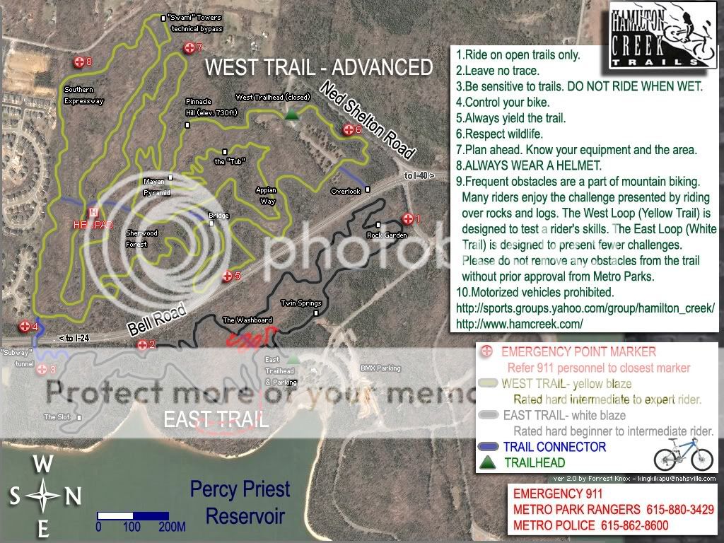
Today, I rode part of the East or "easy" side of Hamilton Creek and found out what technical means. Rocks and roots with the occasional tree thrown in. This loop, which sits on the east side of Bell Road next to Percy Priest Lake, is billed as follows:
The Lakeside Trail (sometimes referred to as the “Novice Loop” or “East Trail”) winds through 3.3 miles of cedar groves and limestone rock outcroppings giving the rider a unique “single-track” experience. There is nothing “novice” about this trail. Some features and challenges of this trail include log jumps, the “Triple Op Drop,” the “Photo Op Drop” (where riders frequently take pictures of fellow riders riding off this two-foot drop), and “The Slot” (aka: Rock Moguls Field). When rehabilitation of this trail is complete, the Lakeside Trail will stretch about 5 miles with more views of the lake.
Though I thought I followed the trail signs correctly, once I got home and compared my Garmin track to the trail map, I realized that I had only ridden the upper half of the East Loop. Oh well, the unseen portion will give me something to look forward to next time.
I ran this upper section twice, so I did total a little over 3 miles. On the first run, I purposely came out of my clips probably a dozen times, mostly in vertical ascents/descents with a high granite factor. I was pretty cautious, given that I was riding alone and that there were only a couple of cars at the trailhead. On the second attempt, after I'd seen some of the lines, I took it to some rooty/rocky climbs and ground them out. This time, I kept count and found that I had to walk my bike over/around 6 spots--either jumps, rocky stretches where I couldn't find the line, or in one case, a big tree. There weren't that many runs where I could just let it out and flow with the trail until the very end of my loop. Maybe there are more in the south section I didn't ride.
It's not a track for beginners, but it's rideable for me since I have no problem swallowing my pride and walking the bike in spots. Of the 6 places I dismounted, there are a couple that will take a while to master. Still, I'll go back and work on the East Trail. It's close by, and it's a fair test of my skills at this point. I don't know if I'm an "advanced beginner" or an "intermediate" rider, but I think that, with some practice, I can get it around that trail pretty soon.
Well, if it weren't for the big tree...


Hamilton Creek East at EveryTrail
Map created by EveryTrail: Geotagging Community
Subscribe to:
Posts (Atom)